Weather Fronts
What All Sailors NEED To Know
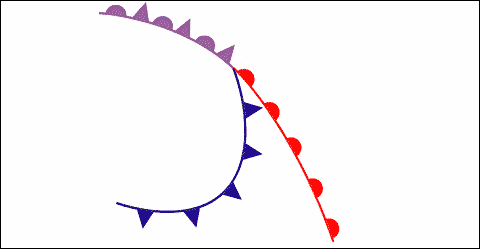
A weather front is the boundary line between 2 different air masses – one cold and the other warm. These air masses do not mix with each other but rather move with each other in an intricate balancing act. On weather maps, the boundary line is shown as a particular line as in the accompanying illustration. (warm front = red line with semi-circles; cold front= blue line with 'teeth')In the Northern Hemisphere, winds rotate around the centre of a Low in an anticlockwise manner, spiraling in towards the centre of the depression, crossing isobars at about 20°.
Lets look at a sailboat in each of the six locations marked. As the boat moves from position 1 through to position 6, it will experience significant changes to weather.
In position 1, the skipper will experience winds out of the SSW. The wind will blow parallel to the isobars and are backing. The winds will be moderate as the isobars are well-spaced. As you sail to location 2, the isobars become closer which means the wind is picking up speed. Also, the wind is backing or changing direction from SSW to more southerly. Finally, because you are approaching a front, the barometric pressure will be dropping. These three factors – increasing wind strength, wind backing and barometric pressure falling – are all solid indicators that you are approaching a warm front.
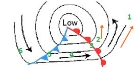
In location 2, you are immediately in front of the warm front. Here warm, less dense and moisture laden wind attempts to rise up over colder air in front of it. High cirrus cloud is the first sign of the approach of an active warm front. Cirrostratus soon follows (the high thin cloud which causes a halo around the sun or moon). The cloud gradually thickens and the base lowers until a solid deck of altostratus/altocumulus covers the area. Low nimbostratus moves in, merging with the altostratus. As a result, a solid deck of cloud extending from near the surface to 25,000 feet or more covers the whole area. Precipitation is usually heavy.
At position 3, the warm front is passing through your location. From the diagram, you can see that the wind veers sharply, moving clockwise from a southerly direction to out of the west. Clouds will be heavy but rain will decrease. Also, the barometer will stop falling.
Position 4 is located within the warm sector. As warm air
holds more moisture than cold air, you will likely experience a steady
drizzle accompanied by very poor visibility. The Low pressure zone will
usually track parallel to the isobars in its warm section. Therefore,
you can expect steady wind strength and direction. As you are moving
parallel to the isobars, the barometric pressure will be steady as well.
At position 5, you are at the cold front. The clouds will be very
heavy and dark. Thunder and lightening are good indicators that a cold
front is bearing down on you – a good hint to shorten sail immediately!
One thing to notice is the sudden shift in the wind. In our
illustration, you can see a pronounced veering from W to WSW. This will
also result in confused seas which can be very rough and choppy. Because
the denser cold air is trying to force its way under the warmer air,
the drizzly, foggy conditions of the warm sector, hallmarks of low-lying
stratus clouds, give way to soaring cumulonimbus clouds at the cold
front. These clouds can reach from close to the surface all the way up
to the top of the troposphere where they flatten out to their
characteristic 'anvil' shape. As mentioned above, cumuloform clouds are
caused by vertically rising air and are unstable by nature. Cumulonimbus
clouds are the biggest of this class and are the most unstable. Their
presence is marked with high, shifting winds, intense squalls, heavy
rain and thunder and lightening.
In position 6, the cold front has passed and the air
clears. Temperature will drop and you will see your barometer rise as
you move away from the Low. The wind will have shifted and will now be
steady.
So, can we summarize this? I think so:
- You will see a warm front approaching from miles away. Those high, wispy cirrus clouds are the tell-tales.
- When a warm front passes over you, you are going to get wet! When you are in the warm sector, you are going to get wet ... and see less.
- When the cold front passes over you, you are going to get very wet and you are going to deal with strong, rapidly shifting winds, intense rain, really confused seas and quite likely lightening – shorten sail early, batten the hatches, get on your foul weather gear, a lifejacket and a safety harness.
Click here to return to WEATHER
Click here to return HOME
The Complete Log Book For Cruising Sailors
written by a sailor for sailors

a practical, easy-to-use yet thorough format to record all of the necessary information about your boat and any cruises you take – whether exploring home waters or voyaging to distant ports across the Great Lakes.
.
Click here for more details