Navigation Tools
There are certain navigation tools that are essential. It goes without
saying that every cruising boat should have a properly swung compass.
That means a compass in good working order where the deviation is known
and recorded. I have been on boats where the compass reading was off by
as much as 30°. For all intents and purposes, that compass is useless to the navigator.
The ship's compass should be backed up with a hand-bearing compass. This back-up navigation tool has a number of purposes.
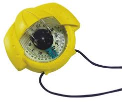 |
Obviously, it can be used if the ship's compass is ever damaged. It can
be used to take sights as well as help determine leeway. This can be
pistol-grip style or the hockey puck style or a simple hand compass.
Whatever you use, it should be able to be easily aimed and read – my
preference is for a pistol-grip style but individual tastes will dictate
here. |
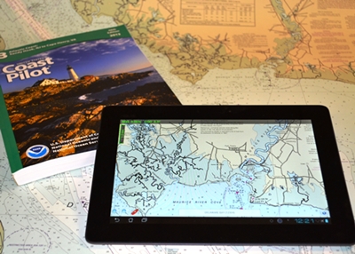 |
Another basic navigation tool is a navigation chart(s). Every sailor should have up-to-date charts of the waters they sail in. This does not include, as I have seen, provincial or state road maps or printouts from Google Earth! In Canada, The Charts and Nautical Publications Regulations require pleasure craft |
operators to have on board at all times the latest, large scale charts and required publications, such as Chart 1 for the waters in which they are operating.
The only exemption is where the Master has local knowledge of the water in which s/he is operating. This is a subjective issue and, in any type of legal hearing, expect that your 'local knowledge' will be put to a withering test.
United States recreational vessels are not required to carry navigation charts. Obviously, I believe that it is vital to always have the necessary publications on board. Certainly, any prudent sailor will have them on board.
|
In the RESOURCES section, there are downloadable copies of each Chart 1. Click here for: |
There is a standardized set of symbols that are used. It is not really
possible to memorize them all but it is clearly useful to know the most
common ones. The symbols are listed in Chart 1 (both Canada and the United States have a Chart 1) as well as the British Admiralty Chart 5011.
(Chart 1 will help you in identifying that strange 'squiggle' that is
looming in your path!) If you are going to be doing any cruising, have
these on board.
|
|
In addition to charts, there are some other basic navigation tools you should have. |
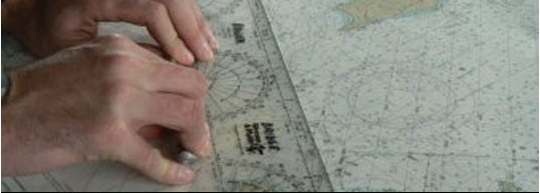 |
A math kit with dividers, soft lead pencils, an eraser that doesn't smear (you can tell this is a small personal irritation!), ruler(s), parallel rules (or a plotter such as a Breton Plotter), a simple calculator and recipe-style cards. You do not have to spend a lot of money on these.
My most expensive piece are my dividers which are large, brass with stainless steel tips. I have had them for decades. The rest are part of a good math kit bought at an office supplier for less than $25.00 They are used only for navigation. The recipe cards are for certain notes that I want to make and keep close at hand for continual reference.
My
kit also includes a decent-size magnifying glass, and a small red/white
lens flashlight. If you wear glasses, keep a cheap pair of 'readers' in
your kit as well. You should have a good timepiece. Personally, I like a
watch with a large face and a good sweep second hand but use what you
feel most comfortable with. And cost isn't the issue here – mine was
less than $10 and years later keeps accurate time. All are kept in a
case that has room for a pad of paper, can hold some reference books and
is easily portable. Weems & Plath have a "NaviTote" that was designed with input from the U.S. military. It is an excellent piece of kit to keep navigation tools close at hand and in good order. You can see it in the STORE.
Electronic navigation aids have greatly aided
sailors and definitely have a place at the NAV station. However, I
believe that all sailors should have an understanding of the principals
of navigation without recourse to electronics. After all, they could die
on you, couldn't they? (A Canadian Coast Guard Auxiliary Search and Rescue vessel had its
entire electronics suite go dark during an exercise in mid-autumn on a
stormy Great Lake. Well out of sight of land and with rain significantly
reducing visibility, the Captain conned her safely back to harbour using
exactly these navigation skills.)
Return from Navigation Tools to NAVIGATION
Return to HOME
Check out our great deals on high quality navigation tools from Weens & Plath and Davis Instruments
Name Brands Quality Products
Click the STORE button on the navigation bar
Join hundreds of fellow
sailors
Subscribe to Rhumb
Line for updates and new port reviews
Your e-mail address is secure.
It is used only
to send you
Rhumb Line
The Complete Log Book For Cruising Sailors
written by a sailor for sailors
a practical, easy-to-use yet thorough format to record all of the necessary information about your boat and any cruises you take – whether exploring home waters or voyaging to distant ports across the Great Lakes.
.
Click here for more details