Aids to Navigation
Your 'highway' on the water
In the 1970's, the International Association of Lighthouse
Authorities (IALA) organized an international agreement on buoyage and
navigation lights world wide. Until that time, there was a confusing
patchwork of national systems. Things came to a head with the occurrence
of 2 wrecks in the Dover Straits in the same location which cost over 50
lives, despite a number of prominent markers.
As you can well
imagine, getting a unanimous agreement was impossible and the end result
was 2 regions. Region A covers Europe and most of the rest of the
world. Region B covers the Americas, Japan, the Philippines and South
Korea. The only difference between the Regions is the direction of
buoyage. In what follows, we will be referring only to Region B as that
is what applies to us on the Great Lakes
IALA identifies Aids To Navigation (ATON) by 4 characteristics:
- shape
- colour
- topmark
- lights
During daylight hours, Aids to Navigation are identified by location, shape, colour pattern and any additional specific features such as RACON (radar transponders) or by specific numbering.
At night, Aids to Navigation are identified by use of lights. Lights are identified by 3 characteristics:
- colour
- period (time in seconds to complete 1 cycle of the relevant pattern)
- phase (the particular pattern assigned to a specific light)
Here are the characteristics defined for lights on the Great Lakes.
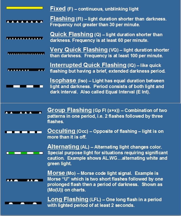
NAVIGATION BUOYS
Navigation buoys fall into 6 types:
- lateral
- cardinal
- isolated danger
- safe water
- wrecks
- special
All
directions are based on whether you are returning from the sea (going
upstream or heading into a harbour) or heading out to sea (going
downstream or heading out of a harbour) In our case, the sea is the
Atlantic Ocean via the St. Lawrence Seaway.
IALA B uses the lateral system in which the buoys mark the limits or 'edges' of the
channels. Cardinal Buoys are also used which denote the direction of
safe water.
Aids to Navigation are marked on the chart with a
teardrop shape and, if lit, will be magenta in colour (easy to read
under a RED night vision light). The exact location is the small circle
or dot at the base of the teardrop.
 |
The basic rule in the Lateral system is 'RED RIGHT RETURNING'.
If you are returning from the sea – that is, going upstream or into a
harbour, you keep the RED buoys on your starboard. RED buoys are cone
shaped (also referred to as nuns)and, if lit, will have a RED light.
Numbering will be even numbers. A RED daymark will be triangular in
shape. |
 |
Buoys that mark the port side of a channel when returning from the sea
are GREEN.They are shaped like a can, meaning they are flat-topped (and
referred to as cans). If lit, they will display a GREEN light and be
numbered with odd numbers. A GREEN daymark is square in shape. |
CARDINAL BUOYS
The other major type of Aids to Navigation that you may encounter are Cardinal Buoys. They take their name from the 4 cardinal directions – north, south, east and west. They are used to direct vessels safely around a particular hazard or danger.
Your direction of approach doesn't matter – which makes them different from lateral buoys.The body of a cardinal buoy is always marked with a combination of black and yellow bands. It is always surmounted with a topmark consisting of 2 black triangles arranged in 1 of 4 combinations.
The apex of the triangles point to the location of the black band. Each has a light that flashes a specific pattern. The lights follow a clock face where '3' is east, '6' is south', '9' is west and '12' is north.
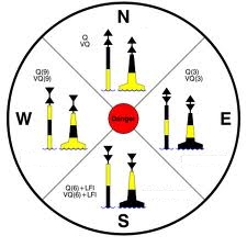 |
The NORTH Cardinal Buoy is Black over Yellow (BY) and the 2 black triangles point UP. This would mark the northern-most extremity of an underwater hazard and indicates that safe water is to the NORTH. A WHITE light flashes Q (quick) or VQ (very quick) continuously. The EAST Cardinal Buoy is Black over Yellow over Black (BYB) and the 2 black triangles point AWAY from each other. This would mark the eastern-most extremity of an underwater hazard and indicates that safe water is to the EAST. A WHITE light flashes Q(3) or VQ(3) (3 quick or very quick flashes). |
The SOUTH Cardinal Buoy is Yellow over Black (YB) and the 2 black triangles point DOWN. This would mark the southern-most extremity of an underwater hazard and indicates that safe water is to the SOUTH. A WHITE light flashes Q6 + LFL (6 quick or very quick flashes plus 1 long flash).
The WEST Cardinal Buoy is Yellow over Black over Yellow (YBY) and the 2 black triangles point TOWARDS each other. This would mark the western-most extremity of an underwater hazard and indicates that safe water is to the WEST. A WHITE light flashes Q(9) or VQ(9) (9 quick or very quick flashes). There are other types of buoys that you will likely encounter.
 |
Fairway Buoys mark safe water. They are marked with RED and WHITE vertical stripes. They are used in the entrances or centre of channels. They can be passed on either side but in practice, are kept on the port side. |
 |
BIFURCATION BUOYS are used to mark the preferred channel when confronted with 2 options. They are marked with RED GREEN RED OR GREEN RED GREEN bands. You may pass on either side in the upstream direction. The main or preferred channel is shown by the colour of the top band. As shown, you should keep this buoy on your your port side. |
 |
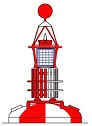
ISOLATED DANGER BUOYS are Aids to Navigation that are used to mark an isolated hazard in waters which otherwise are navigable. They are normally moored directly on or above the danger such as a large rock, shoal or sunken ship. The pattern of bands is BLACK over RED over BLACK. The topmark is 2 BLACK balls. If lit, the light will show 2 WHITE flashes (Fl2). |
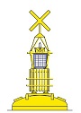 |
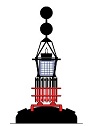
SPECIAL PURPOSE BUOYS are not Aids to Navigation but rather are used to convey information to vessels. They are solid YELLOW. If they have a topmark, it will be a YELLOW 'X'. If lit, the light will be YELLOW and flash once every 4 seconds. They may convey information such as an exclusion zone for a firing range for example or a seaplane base. |
REGULATORY BUOYS are not Aids to Navigation. These too are used to convey information to vessels. They are WHITE cans marked with ORANGE bands near the top and bottom. Between the bands will be 1 of 4 ORANGE shapes which convey information. A cross within a diamond indicates 'Keep Out'. A circle indicates some type of restriction(s) e.g. speed. A diamond indicates danger. A square indicates some information e.g.water ski area.
Click here to return from Aids to Navigation to NAVIGATION
Click here to return to HOME
Check out our great deals on high quality navigation tools from Weens & Plath and Davis Instruments
Name Brands Quality Products
Click the STORE button on the navigation bar
Join hundreds of fellow
sailors
Subscribe to Rhumb
Line for updates and new port reviews
Your e-mail address is secure.
It is used only
to send you
Rhumb Line
The Complete Log Book For Cruising Sailors
written by a sailor for sailors
a practical, easy-to-use yet thorough format to record all of the necessary information about your boat and any cruises you take – whether exploring home waters or voyaging to distant ports across the Great Lakes.
.
Click here for more details